ENVIRONMENTS
Greenbelt
FLOOD risk
green infrastructure
transport links
education
telecommunications
local business
well-being
housing
NEXT STEPS
GET INVOLVED
ANNEX
Traffic Management
Aim
To work positively and collaboratively with local planning authorities to ensure that the traffic management needs of the Parish are met effectively; principally that there are sufficient measures available to identify, mitigate and resolve key issues relating to building developments.
Background
As stated elsewhere in this Plan, Wymondley Parish is bordered by the towns of Stevenage, Hitchin and Letchworth. In 1992, the A602 Wymondley Bypass was constructed to allow traffic flow from Hitchin (and surrounding areas) to access the Corey’s Mill roundabout at the A1(M), Junction 8 (J8), for onward travel south to London, or to Stevenage without passing through Little Wymondley.
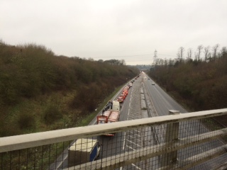
A602 Wymondley Bypass towards Hitchin 07.55 a.m. – 1 March 2016
The main road through Little Wymondley, (Stevenage Road), leads from the A602 Wymondley Bypass at Ashbrook to the Corey’s Mill roundabout, at which point a number of roads coincide, including the slip-roads from and to the A1(M), J8. On the outskirts of Little Wymondley it meets Arch Road and Blakemore End Road at a crossroads, (which is prone to flooding), and where there is a mini-roundabout.
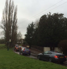
The following photographs show the most recent episode of disruptive flooding at the roundabout, and the resulting tailback from it to Great Wymondley:
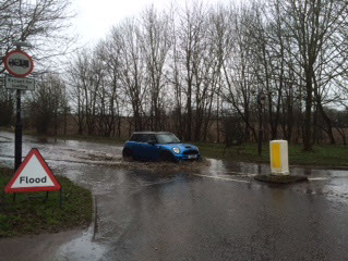
Blakemore End Road roundabout (at Arch Road and Stevenage Road, Little Wymondley) 9 March 2016
Arch Road flooding tailback from Great Wymondley to Little Wymondley - 9 March 2016
Empirical traffic flow evidence regarding “rat runs” in Wymondley Parish indicates that:
- Traffic leaves the A1(M) at J9 (Letchworth Gate), travelling through Willian, Great Wymondley and Little Wymondley and onward, via the lanes and Codicote, to reach A1 (M), J6 (Welwyn).
- Traffic from the Ninesprings area of Hitchin travels along Hitchin Road to the Green Man intersection at Great Wymondley, and continues through the village along Arch Road to Little Wymondley, where it joins Stevenage Road at its junction with Blakemore End Road.
- From there, the rat-runs continue either left along Stevenage Road to Corey’s Mill and beyond; or straight across the crossroads and onward to Stevenage, via the hamlets of Redcoats, Titmore and Todds Green.
The issues
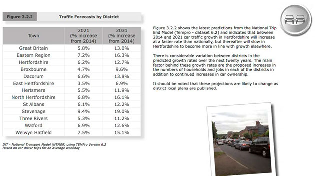
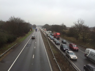
The A1(M) is clearly inadequate for the current volume of traffic using it, particularly at peak times. This fact has been recognised by HCC and other relevant authorities , (see Annex 6 and screen shot below), and is clearly highlighted by the resulting rat-runs created on the roads and lanes within Wymondley Parish by motorists trying to avoid the congestion.
Detrimental consequences of the inevitable, (at least) twice-daily tail-backs of traffic from Corey’s Mill and rat-run usage include: increased noise, critically poor air quality and risk and inconvenience for parishioners experiencing difficulty in entering or leaving their driveways; crossing the road, or safely entering Corey’s Mill roundabout itself.
Unsurprisingly, traffic management was highlighted as a major issue in our parish survey – with 70% of respondents seeking improvements to it. Suggestions included traffic calming measures (such as increased speed restrictions on the Stevenage Road); safety measures such as traffic lights at the Stevenage Road junction with Corey’s Mill; and pedestrian footbridges/underpasses in relation to the A602, Corey’s Mill roundabout - and to link Titmore Green with Little Wymondley.
In the light of feedback from our parish survey, and to inform this Neighbourhood Plan, we undertook a series of ad hoc Traffic Surveys at points in the Parish known to have significant traffic issues. The photographs included in this Plan, together with the survey results shown at Annex 7, indicate the levels of traffic using parish roads to try to circumvent the inadequacy of both the A1(M) generally - and J8 in particular
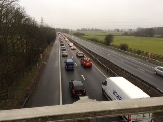
A1 (M) South 08.09 a.m. – 1 March 2016
A1 (M) South 09.05 a.m. – 1 March 2016
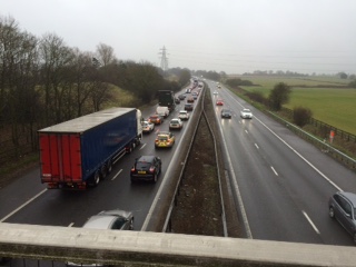
A1 (M) South (from other side of the bridge) 09.05 a.m. - 1 March 2016
Safety issues
We have been informed that there is no prospect that the capacity of the A1(M) will be increased before 2031, save upgrading the motorway to smart status, whereby the hard shoulders of the motorway will be used as additional lanes. This being so, there will undoubtedly need to be better traffic control at the A1(M) J8 junction, to address not only congestion issues, but also related health and safety concerns.
Access onto the Corey’s Mill roundabout from both Little Wymondley and Graveley is not currently traffic light controlled. Motorists accessing the roundabout from the preceding roads and traversing the traffic lights at amber, (and frequently at red), shorten the available time for egress from Little Wymondley and Graveley onto the roundabout.
Policy TM1: We support the need for safety cameras on the Corey’s Mill traffic lights to deter “red light runners”, thereby giving increased time and opportunity for motorists from Little Wymondley and Graveley to access the roundabout safely. We also support the need for traffic lights at those two junctions with the roundabout
Traffic calming
Associated traffic noise reduces the appeal of the Parish for residents and visitors; and affects their quality of life. Accident and speeding incidents on the road network are a cause for concern amongst residents and businesses, and there is a need to improve the network at certain locations to address these issues.
Traffic calming can employ a variety of methods, depending on the desired outcome. Its main purpose is to reduce the flow of traffic which, in turn, has the desired effect of reducing speed. Both issues were identified by our survey as a concern of residents - who called for traffic calming measures, including speed restrictions on Stevenage Road in Little Wymondley.
All roads leading into Wymondley Parish are unrestricted single carriageway roads, which pose additional problems with speeding through the villages. There are several pinch points (build-outs) intended to reduce speed, located on Hitchin Road and Arch Road in Great Wymondley; and along the Stevenage Road in Little Wymondley. However, these pinch points are ineffective at reducing speed through both areas, as they do not restrict the flow of traffic in either direction effectively. (They can have the reverse effect, as oncoming vehicles often speed up to beat oncoming priority traffic.)
Changes in speed have been shown to bring about reductions in injury accident numbers. A good rule of thumb is that a 5% reduction in injury accidents can be expected to result from a 1 mph reduction in mean speed (Taylor et al, 2000). The reduction varies according to road type, and is 6% for urban roads with low average speeds; 4% for medium-speed urban roads or lower-speed rural main roads; and 3% for higher-speed urban roads or rural main roads.
In some traffic-calmed areas, personal injury accidents have been reduced by 60–70% cent following speed reductions of about 9 mph. The proportion of accidents that are fatal or involve serious injury has also been reduced (Webster, 1993a; Webster & Mackie, 1996; Barker & Webster, 2003).
Policy TM2: We will work with the Highways Agency, HCC, local planning authorities and other stakeholders to ensure improved traffic calming measures are put in place, in line with Government guidance, specifically the Local Transport Note 01/07
Air Quality management
Local authorities have a duty to monitor the air quality in their district under the Environment Act 1995, because poor air quality has the potential to adversely affect public health.
Our congested local road network undoubtedly increases pollution due to idling traffic, which in turn can cause or exacerbate existing health issues for our parishioners. Elevated levels and/or long term exposure to air pollution can lead to more serious symptoms and conditions affecting human health. This mainly affects the respiratory and inflammatory systems, but can also lead to more serious conditions such as heart disease and cancer. People with lung or heart conditions may be more susceptible to the effects of air pollution.
In March 2016, the BBC produced a news article highlighting that local authorities across the country are failing to meet the central government targets. Particular emphasis was placed on Hitchin, as being amongst the worst areas in the country. (The charts below illustrate the position.)
Air Quality
East England towns and cities that have illegal NO2 levels
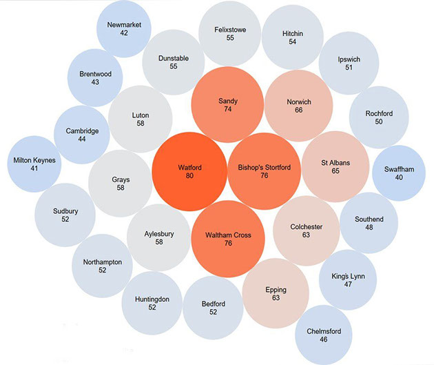
The highest nitrogen dioxide readings recorded at various towns and cities in the eastern region. The legal limit is 40 micrograms in each cubic metre of air
Illegally-high levels of nitrogen dioxide were recorded at more than 50 sites in the east of England, it has emerged. The legal annual mean limit is 40 micrograms of nitrogen dioxide (NO2) per cubic metre of air (µg/m3).
ClientEarth, a group of environmental lawyers, is planning High Court action against the government over illegally high readings. The government said it supported local authorities to tackle air quality.
NO2 is released when fuels such as car diesel or in central heating boilers are burned. There is evidence high levels of NO2 can inflame the lungs and cause long term health issues.
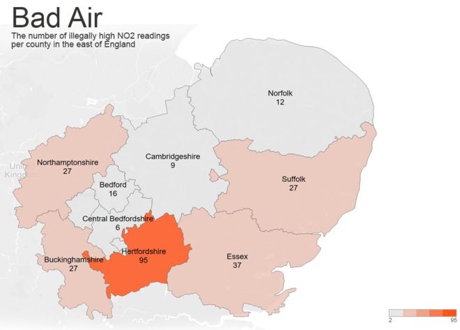
Image copyright Tableau Image caption the number of illegally high readings in the various counties of the east of England
The figures, although illegally high, are a far cry from some readings found in central London where the average annual level of nitrogen dioxide (NO2) in Grosvenor Place, near the Queens central London residence reached 152 µg/m3 in 2014.
Illegally high readings have also been frequently recorded in cities such as Leeds, Birmingham, Southampton and Derby
Alan Andrews, a lawyer with Client Earth, said they had been fighting a legal battle with the government for five years because "levels of air pollution in towns and cities across the UK are above legal levels".
'Create healthier air'
He said Client Earth was now planning High Court action against the government because its plans to deal with the problem were "just not good enough".
"Air pollution is one of the biggest public health issues we face as a society," he said.
"A plan which thinks it is okay for us to be breathing illegally high levels of pollution until 2020 to us isn't good enough and we're pretty confident judges looking at it will feel the same way."
A spokeswoman for the Department for Food and Rural Affairs, said: "Our plans clearly set out how we will improve the UK's air quality through a new programme of Clean Air Zones, which alongside national action and continued investment in clean technologies will create cleaner, healthier air.
Evidence gathered in a report published by NHDC identified congestion corridors that contribute heavily to Nitrogen Dioxide concentration levels. The report states: “The main source of air pollution in the district is road traffic emissions from major roads notably the A1(M), A505 and A602. In terms of traffic congestion the most significant locations are associated with the A505 through Baldock and the A602 and A505 through Hitchin.” The area east of the Three Moorhens Roundabout, on the A602 Stevenage Road in Hitchin is a designated Air Quality Management Area, where regular air quality monitoring is undertaken. More information can be found in the NHDC report, which is available online at:
http://www.north-herts.gov.uk/sites/northherts-cms/files/USA_2015_North%20Hertfordshire%20final.pdf
Policy TM3: we will press for air quality monitoring, and additional safety measures, in relation to the Corey’s Mill roundabout and other key traffic “hot-spots” identified as being of concern to residents.
Parking issues
Due to the nature of the Parish being primarily residential there are no specific car parks for public use. Residential parking takes place on the already congested local roads or on off-street parking spaces on private property. 72% of parish survey respondents wanted improvements to traffic management, including issues such as parking facilities.
As highlighted in Section 12 of this Plan, there are clear concerns about the traffic and parking situation around Wymondley JMI School creating hazardous situations for pedestrians and vehicles, particularly at times when parents park outside the school when dropping off or collecting children. Such situations are well documented nationally as being dangerous to children, parents and residents in the school vicinity.
The road directly outside the School is already designated as a “No Parking” zone between the hours of 08.00 and 17.00 hours; and the entrance to the School is marked with yellow “Keep Clear” road markings which have little or no effect. With few alternatives for parents dropping off children by car, either on the way to work or travelling in from outside the Parish, control methods must be enforced or alternatives sought to prevent accidents from occurring.
Proposals for new housing development in the Parish could have a significant impact not only in terms of increased volume of traffic, but on the need for adequate parking provision. Depending on location, there may be specific implications, not least for parking and traffic management in the vicinity of Wymondley JMI. (Further consideration of these issues is given in Section 16 of this Plan.)
Provision of car parking in shared courts on new developments is generally unpopular with residents, who want their vehicles to be easily accessible, visible and less vulnerable to crime. Sufficient spaces for residents’ vehicles and visitor spaces are also deemed necessary, to avoid conflict over spaces and other parking difficulties.
Accessibility into new developments also needs to be properly considered. It is often overlooked, with roads being too narrow to accommodate parking for residents’ vehicles and the need for service vehicle access, such as refuse and recycling collections, emergency services etc.
Policy TM4: We will work to identify and implement appropriate solutions to local parking problems
The way forward
Wymondley Parish residents have a right to expect the quiet enjoyment of their environment, and this remains a prime requisite of the Neighbourhood Plan. Our traffic management policies aim to help achieve this, together with a quieter, safer and healthier Parish.
Policy TM5: We will study closely any development proposals, impacting on the Parish, to ensure that road infrastructure issues have been properly considered and addressed from project concept to implementation; and where insufficient account has been taken to mitigate the effects of increased traffic we will object accordingly.
