
WYMONDLEY PARISH
ENVIRONMENTS
Greenbelt
FLOOD risk
green infrastructure
transport links
TRAFFIC management
education
telecommunications
local business
well-being
NEXT STEPS
GET INVOLVED
ANNEX
Housing and Other Development
Aim
To promote sustainable development in our Parish, by ensuring any necessary development is well-designed and located appropriately, i.e. where it will enhance or maintain the vitality of our community; reflect the identity of our parish; and respond to its local character and history. Also, through consideration of demographic trends and community needs, and by identifying possible “deliverable” sites within the Parish, we will strive to ensure that any proposed housing is affordable and of a suitable size, type, tenure and range for the community.
Background
We recognise that, in order to help meet the needs of our Parish, consideration must be given to future housing development. This presents us with a significant challenge, given the location and character of the Parish and the need for us to represent the wishes of the parishioners accurately. In rising to that challenge we have taken a pragmatic approach, concluding that to safeguard best what is important to parishioners, we have to consider the unpalatable prospect of development on Green Belt land within and adjacent to the Parish.
However, for the reasons cited in Section 6, (and in line with the Government Green Belt policy), we have focused on possibilities for affordable housing and other facilities through limited infilling or partial redevelopment of brown-field sites; and re-use of existing permanent buildings on Green Belt land. (Green Belt issues are specifically covered in Section 7 of this Plan.)
A conservation area covers most of Great Wymondley village, and this has so far preserved and protected its character from inappropriate development – something we would wish to continue, and which has therefore been a key factor when considering potential development sites within the Parish.
Looking more broadly at the Parish: we are fortunate to have a wide variety of features illustrating its development through the ages, and we believe it is important to protect our heritage for the benefit of current and future generations. We therefore aim to ensure that any proposed development would not have a detrimental effect on them. As Section 6 of this Plan presents a broader picture of the particular historical and archaeological features of our parish heritage – and also deals with identified biodiversity and environmental issues, they are not covered here
Community population and housing need
For the purposes of this Plan we have generally used demographic data taken from the 2011 census, that being the most recent available. (See Annex 8) At the time of the 2011 census, the parish had 480 dwellings, and a population of 1,153.
With regard to the demographic of the Parish population, the 2011 census for North Hertfordshire indicates approximately 32% of the population is between the ages of 16-40; 34% between the ages of 40 and 59; and 33% 60+. We believe Wymondley Parish’s current age demographic leans more heavily towards the older end of the age scale.
We estimate that approximately 30% of Parish housing is public sector, with the remainder privately owned dwellings, some of which are rented. There is a good mix of housing types - with good numbers of 2 and 3 bedroom family houses; and approximately 20% of the existing stock being 1 or 2 bed flats or starter homes, suitable for younger people. There are around ten public sector retirement bungalows in the Parish, (plus other privately owned bungalows), amounting to an estimated 6.5% of our housing stock. The remainder is made up of substantially larger properties and character properties.
Assuming that the Parish population concurs with national demographic trends, this indicates a potential shortfall in suitable accommodation for older parishioners. We believe that any plan to build new dwellings should reflect the needs of the community, and seek to address the current imbalance in terms of property type and tenure. A mix of affordable public and private sector retirement bungalows would therefore seem to be ideal, although more work may need to be done to confirm this.
Policy HOD1: In considering housing proposals impacting on the Parish we will consider demographic trends and community needs, and work with stakeholders to ensure that any housing delivered meets community needs in terms of affordability, type, tenure and range
Community population and housing need
Responses to our survey, and discussions at local meetings on the issue, indicated a reluctant acceptance of future development, with many respondents commenting that they did not want to see any development at all. When asked how many homes they felt it would be proportionate and reasonable to build, 76% of respondents took the view that 50 or less was the appropriate number, (this being the minimum option offered for people to choose).
The overwhelming feeling in the Parish is that any development must be proportionate to the size and character of the Parish; appropriate in terms of type and location; suitable for parishioners; and affordable and available to them. Essentially, no more than 50 dwellings of the right type, in the right place, at the right price.
Policy HOD 2: In considering planning applications and other development proposals impacting on the Parish we will work to ensure that developments are well-designed and located appropriately, i.e. where they will enhance or maintain the vitality of our community; reflect the identity of our parish; and respond to our local character and history.
Opinions voiced at the Parish public meeting held on 26th October 2015, (where the results of our parish survey were made public to the residents of the Parish), were robustly against any suggestion that 300 (or more) dwellings would be a proportionate or reasonable number to add to the Parish. Such numbers, particularly given the locations currently proposed by our accountable and neighbouring councils would be wholly disproportionate to the existing settlements. Aside from the fact that they fly in the face of Government Green Belt policy, they would undoubtedly have a detrimental effect not only on the rural environment and intrinsic character of the Parish, but on its social and economic well-being and the quality of its parishioners’ lives. Crucially, a number of pre-existing environmental and infrastructure problems, (covered elsewhere in this Plan), would be exacerbated.
The above figures cannot be viewed in isolation. They must be considered as part of the bigger picture, i.e. our overall objective of sustainably meeting the needs of our parish, while seeking to preserve its rural environment and intrinsic character. The clearest mandate (92 % in favour) arising from our survey was that the existing Green Belt, (which prevents our villages being subsumed into Stevenage or Hitchin via their urban sprawl), should be preserved.
Having taken this and the Green Belt requirements into account, together with the principles of sustainable development and the relevant over-arching factors specific to the Parish, we identified and considered potential development options within the Parish – dividing them into the following categories:
a) Green Belt – areas for consideration to convert existing buildings (brown-field sites) into dwellings;
b) Non-Green Belt – areas for consideration to convert business units into dwellings;
c) Non-Green Belt – areas for consideration for additional parking facilities; and
d) Non-Green Belt – areas for consideration for additional children’s play areas.
Green Belt – areas for consideration to convert existing buildings
(brown-field sites) into dwellings
We believe there are several agricultural buildings on various Green Belt sites within the Parish, which are open to possible conversion to dwellings if they are classed as brown-field sites. The photographs below show three which have so far been identified, namely:
a) Existing units near the allotments on Stevenage Road;
b) Farm buildings on Wymondley Hall Farm; and
c) Redcoats Farmhouse – where planning permission has already been granted for conversion of semi-derelict barns to residential accommodation. These barns are currently for sale with the Planning Permission.
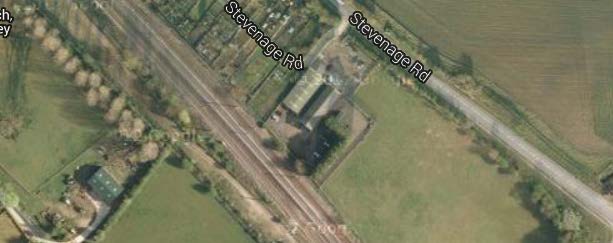
Units on Stevenage Road, near the Allotments
Wymondley Hall Farm
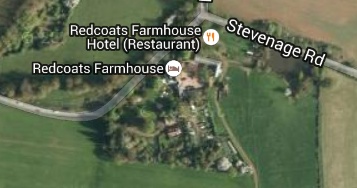
Redcoats Farmhouse
The relevant landowners will be specifically consulted on this draft Neighbourhood Plan, in line with our statutory obligations. Any development proposals for these sites will be considered in the usual way, in the light of relevant Government and other policies – including those contained in this Plan.
Non-Green Belt – areas for consideration to convert business units into dwellings
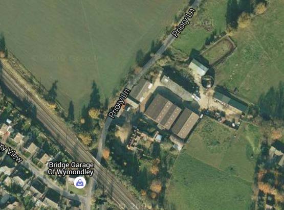
We considered the possibility of converting existing business units in Elms Yard, (and two other small business premises in Priory Lane), Little Wymondley into dwellings. However, given the arguments in favour of supporting local business and employment, (see Section 14 of this Plan), we did not feel it was appropriate to suggest redevelopment of established and thriving local businesses.
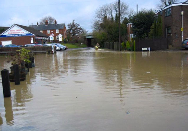
Additionally, while the two adjacent business sites in Priory Lane, (located near an existing residential area) may be suitable for a small number of dwellings with off-street parking, the undoubted flood risk may render them unsuitable, unless adequate control measures are in place to prevent further such incidences.
Non-Green Belt - Areas for consideration of additional parking facilities
Insufficient parking facilities are a current bone of contention within the Parish, particularly in the Wymondleys. A large percentage (70%) of our survey respondents sought improvements to traffic management, including parking, and we therefore considered options for developing brown-field sites to provide increased parking facilities within the Parish and alleviate concerns.
There are designated public parking areas in Little Wymondley, adjacent to the Tennis Club and football pitches on the Queen Elizabeth II Playing Fields, but these are exceptionally small for the facility itself. Other than that, parking facilities are residential, (as described below); attached to specific premises for use by their business customers or churchgoers; or on the public highway.
Many streets in Little Wymondley were built in the 1950’s and earlier, so many houses have no direct parking facilities. Approximately ten years ago, NHDC added driveways to some houses on the north side of Grimstone Road, but these were generally single-space driveways, and most houses now have two or more cars. The council did not add driveways to the south side, nor on the adjoining Siccut Road, where parking facilities are still inadequate and there is general on-street parking on the public highway. Most of the privately owned houses have driveways, but by no means all, so installation by NHDC of additional driveways where appropriate may be a positive way forward in alleviating on-street parking problems in the vicinity.
Any increase in housing development and/or reduction in current available ad-hoc off-street parking opportunities would undoubtedly exacerbate the current parking situation. Issues relating to the inevitable increase in the volume of traffic passing through the village are primarily covered in Sections 10, 11 and 12 of this Plan. We believe there would be a corresponding increase in risk to the health and safety of children using Wymondley JMI School, (and to those who regularly use the adjacent green spaces and recreational facilities) if traffic congestion increases in Siccut and Grimstone Roads; or more on-street parking becomes necessary there.
Another unintended consequence of any increase in on-street parking in Siccut and Grimstone Roads will be that the road becomes obstructive to large vehicles such as buses, waste collection vehicles and emergency services vehicles. There is already evidence of these vehicles struggling to get through at present, with large stretches of the grass verges on the south side of Grimstone Road being driven on and churned up, causing water drains in the road to block and the road to flood under moderate rainfall. Apart from the obvious health and safety issues, there would be a negative impact on those parishioners who use the local bus service, (particularly elderly residents of the retirement bungalows), were the bus service to be withdrawn as a result of the road becoming impassable for such vehicles.
North Herts Homes (NHH) owns an area of land behind Siccut Road, which contains a green space (formerly allotments), and 30 parking spaces which can be rented by village residents. Garages originally stood on each of these spaces, but many were removed when the land was sold to NHH in 2003; and must now be removed as and when individual spaces are given up by residents. Further garages may not be erected, but residents are still utilising the spaces to alleviate the parking congestion on Siccut/Grimstone Roads.
Elms Close and Tower Close, (both in Little Wymondley), also have inadequate residential parking facilities. Elms Close has driveways/allocated parking for all dwellings, with a large car park adjacent to the flats. However, as with Grimstone and Siccut Roads, the parking arrangements provide for only one car per dwelling – whereas most households tend to have more. Consequently, the parking facility is barely adequate for current needs, and frequently necessitates residents double-parking.
Tower Close dates from 1921, when cars were not commonplace, so some houses have driveways, but approx. 50% do not, and most residents currently park on-street outside their houses or in the lay-by areas around the central green. (There is another lay-by towards the Stevenage Road end of the Close, which is badly maintained and therefore discourages parking there.) Some residents of Tower Close have requested an increase in parking facilities there - particularly at the top of the Close, where there is little on-street parking available and the steep gradient causes problems for less able residents, if parking spaces are unavailable near their homes
We considered the possibilities for additional parking facilities, and identified three potential sites, photographs of which are provided in Section 9 or below. These are:
a) the NHH land including a green space (formerly allotments) and garage plots in Siccut Road;
b) a grassed area in Tower Close between Numbers 4 and 6; and
c) additional parking spaces to be created at the top of the central Tower Close green.
Option a) above would involve conversion of an existing, unused green space adjacent to the council-owned garages in Siccut Road; and potential use of vacant garage plots in the same location. The parking arrangements on this area would need to be redesigned to increase the number of garages/spaces available, possibly by building new ones that back onto residents’ gardens, to make better use of the land and alleviate the on-street parking problems in the nearby roads. However, this may necessitate termination of existing contracts for rental of the parking spaces, removal of the existing garages and aggravating tenants and parking problems as a result – so is unlikely to be a viable option.
The site is currently unsuitable for residential development, as the entrance does not meet current legal requirements for emergency services’ vehicle access. (Annex 9 refers.) There is little scope for widening because of the houses either side. Given its location, we are now proposing to apply to have the green space, (which was formerly allotments), designated as a Local Green Space (see Section 9), so that it can once again be managed and used by the community.
Options b) and c) aim to improve the parking issues in Tower Close, and propose the creation of some additional spaces by removal of the grass verge between numbers 4 and 6, Tower Close; a small reduction in the central green at the top of the Close (and some slight amendment to the design of the existing lay-bys) to increase parking space; and allocation of parking spaces (to ensure those with health problems can park near their residences in light of the gradient). We will consult residents at a later stage to ensure any re-design plans meet their needs.
The Tower Close central green, although not designated as a village green, is a fairly substantial green space, which contains a number of large trees and is a key environmental and recreational asset to the Close and village. It is regularly used by children living in the Close (and elsewhere in the village); and by local dog walkers. There are currently parking lay-bys on either side, which are used by those residents without garages or other off-street parking facilities; and there is scope to alleviate local parking issues slightly, by making a small reduction at the top end of the green.
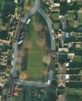
Tower Close, Top of Green and Grass area No’s 4&6
Redesign of the existing lay-bys (including the one further down the road), plus removal of the wide grass verge between numbers 4 and 6 Tower Close would also assist. However, this would mean loss of a cherry tree, and consideration of any related environmental implications or structural impact on the nearby houses relating to its roots etc.
Section 9 of this plan sets out our proposal to apply to NHDC to have this green designated as a Local Green Space, excluding a small portion which could be used for additional parking spaces, as described above, without detriment to the overall appearance and use of the green space and its locality.
Although there could be scope to build a very small number of dwellings and linked parking facilities on the green, this would significantly alter the character of the road, which was laid out along garden city lines in 1921. It would also mean loss of a well-used green amenity, with the reduction in recreational opportunities for the village children, who play on and around the green daily outside the winter months.
Policy HOD4: We will continue to explore opportunities to increase available parking within the Parish and, when considering development proposals, work with relevant parties to ensure that adequate parking facilities are included in plans.
Non-Green Belt - Areas for consideration of additional children’s play area
Section 15 of this Plan covers social cohesion and well-being; and retention and extension of community amenities, including recreational facilities. Responses to our parish survey (58%) indicated that parishioners were keen to have additional children’s play areas, which would be beneficial in encouraging children to engage in healthy, outdoor activities; provide a meeting place; and generally improve fitness, well-being and social cohesion in the Parish.
Three potential locations for additional children’s play areas were considered. Section 9 contains photographs of these sites, which are:
a) The green space (formerly allotments) and council-owned garage plots in Siccut Road;
b) Siccut Road Green; and
c) the Tower Close village green (near Stevenage Road).
Option a): has been covered in conjunction with potential developments for the existing green space and garages at Siccut Road, but has limited potential due to health and safety and access issues. (See paragraphs 16.27 and 16.28 above.)
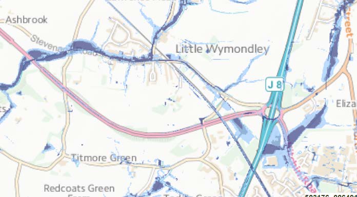
Option b): considers the potential for an additional play area to be created on part of the green in Siccut Road. This land is designated as a village green, and used as a recreational area, particularly for village functions. It is also a flood plain (see the Environment Agency flood map below), so inappropriate for development in terms of dwellings or car parking. However, it would be ideal as an additional play area, as it already contains a wooden, seated play boat – and would be enhanced by the addition of other equipment such as swings, climbing frame etc.
Tower Close, Top of Green and Grass area No’s 4&6
Siccut Road village green has play equipment located there. The Tower Close village green may also have potential as an additional children’s playground as, although it is close to Stevenage Road, its designation as a village green rests on its use by generations of villagers for a variety of activities.
Policy HOD5: we will give further consideration to the provision of additional facilities for the Parish’s children, to determine the most appropriate location(s) and type.
Impact assessment
Although we are not a regulatory body, we feel it is only right and proper that the impact of proposed development should be assessed in relation to the key economic, social and environmental features of the area to which they relate. This would include looking at any disproportionate impact on different parts of society likely to be affected; impact on social, well-being or health inequalities; impact on provision of facilities or services that support community or cohesion, or in other ways that affect the quality of life in the local community. There may be unintended consequences to consider, (e.g. increased opportunities for crime), things that could go wrong, but also things that might work out better than expected. A whole host of environmental issues also fall to be considered – the most salient to us being rural v urban issues; water pollution; levels of water extraction; exposure to flood risk, air quality, infrastructure issues, safety and bio-diversity.
At this early stage, the above options are put forward merely for consideration, so that they may be aired, and discounted or pursued – with a view to further work being done at a later stage, dependent on stakeholders’ views. At that time, we will ensure that a more detailed and wide-ranging, proportionate assessment is undertaken of the impact of any development proposals on the quality of life within the Parish.
Policy HOD1: We will work positively and collaboratively with local planning authorities in considering planning applications, and other development proposals impacting on the Parish, to identify and resolve key issues affecting long-term sustainability.